DTLA Arts District in 360° Panorama Series: Kim West “The One with the Bubbles”

“The One With The Bubbles” is a whimsical mural by artist Kim West that can be found on East 3rd Street on a wall that is sandwiched between Wurstkuche and the Apolis Common Gallery.

Peace Goddess
by Shepard Fairy

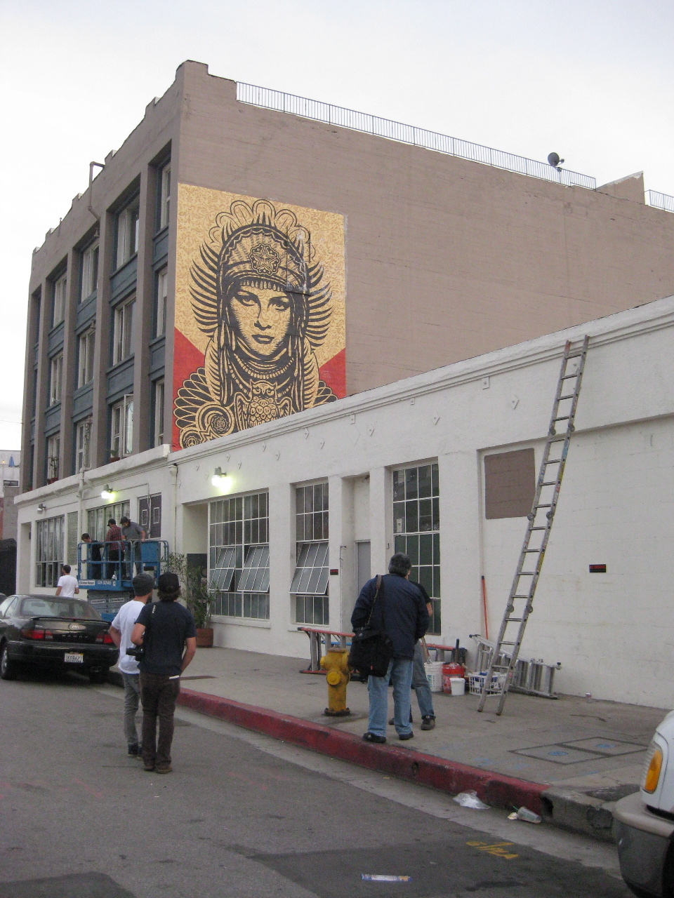
If you look up to the left you can catch a glimpse of Shepard Fairey’s “Peace Goddess” which is part of the LA Freewalls Projects. Turn to your right, look down the street and you’ll see in the distance a mural entitled “Cream of the Crop”, a collaborative piece by Dabs Myla and How and Nosm.

West said in making this mural: “I always have a plan when beginning a painting on an outdoor wall. But just like when working on canvas or paper in the studio – sometimes the idea works, and sometimes it doesn’t. Stressing about whether the plan is going to go well or not while making the work is not constructive, and I have to work hard at keeping that negativity at bay while making decisions. There’s also the issue of leaving the work in an unfinished state at the end of a day. Out in the open. It freaks me out.”

Below is a video of the artist’s process.

DTLA Arts District in 360° Panorama Series: The Mona Lisa of the Arts District

The Mona Lisa of the Arts District by graffiti artist Thomas Burns is located at Traction Avenue and Rose Street in DTLA. 

Photo LA Times

Though it may be impolite and completely un-pc to say this, the truth is she’s a bit old having been gracing the side of this building since Burns was commissioned to do the mural on behalf of a production company filming a soft drink commercial in May 2008. Six years later the paint has begun to peel and her age is beginning to show.

By the end of 2013 taggers and bombers had taken to laying down another coat of paint and throwing-up wheatpaste posters making it difficult to discern that once upon a time the grand dame was sporting a Dali-esque mustache. (Image right)

At the start of the year, the Downtown Muse posted this prognostication about the fair lady’s fate on Instagram by saying: “I predict #MonaLisa #mural won’t last 2014 #artsdistrict #dtla #RoseSt #streetart”.

A follower by the handle “championmarty” remarked, “No respect, Mona Lisa smile is what made it.. They had to go right over her mouth.. Rude”.

Rude, maybe. But oh, baby it’s wild world and it’s hard to get by on a smile.

A search on Google maps offered this image (below) of her younger days.

Earlier iteration of the Mona Lisa of the Arts District on Google Maps.
UPDATE: Three weeks later, this piece was completely rebooted!

DTLA Arts District in 360° Panorama Series: B.B. Bastidas ”Pluto”

Over the New Year I had an opportunity to revisit the Downtown Los Angeles Arts District and for the next few days, I will be presenting a series of 360° panoramic images of some of the neighborhood’s murals.

The area initially was used to grow grapes and by 1849 was the largest producer of wine in California but by the turn of the century oranges and grapefruit became the staple produce. In fact, in 1909 DW Griffith filmed parts of In Old California, Hollywood’s first feature film, in the area’s citrus groves.

By WWII, factories and the rail freight industry supplanted the groves. But the area morphed again during the 70s when the artist movement began to take root and the creation of illegal live-work spaces was developed at a time when space was available at a mere nickel per square foot.

Recognizing the need to regulate the housing situation, the City of Los Angeles passed the “Artist in Residence” or “AIR” ordinance in 1981 that legalized the residential use of formerly industrial buildings for artists.

It was during this period and throughout the 90s that the area was known for its raw and edgy art scene and the crown jewel, such as it was, was Al’s Bar where punk-rock and alternative bands including the Red Hot Chili Peppers, Nirvana, the Fall, Sonic Youth, Beck and the Misfits performed on the dive bar’s stage before making it big.

Real estate prices were still affordable by the turn of the millennium when many of my San Francisco artist friends relocated to the area after the dot bomb as prices for properties were still dirt-cheap.

Today the community has made a noticeable shift as wealthier residents and up-scale businesses have increased property value. Notable residents (past and present) include George Herms, Paul McCarthy and Shepard Fairey, writer filmmaker Frank Miller, singer Meshell Ndegeocello, actors Forrest Whittaker, Jenna Fischer and Dave Foley to name a few.

Needless to say, the real estate here has become exorbitant and community leaders are struggling to balance the economic opportunities offered by gentrification with the need to preserve the essential tone and character of the Arts District as a true creative community.

Over the next few days I’ll be posting panoramic images specifically located at the heart of the art’s district.

Today’s mural by B. B. Bastidas entitled “Pluto” measures 15′ x 30′. Located on Garey Street at 3rd.
New In Reseda: Albert Einstein Mural by Levi Ponce


Yesterday, artist Levi Ponce completed work on his latest mural featuring a portrait of Albert Einstein located behind the Magnolia Science Academy on Sherman Way in Reseda, California. This location is also noteworthy for the film “Boogie Nights” which was also filmed here.

Ponce is a rising San Fernando Valley artist who is best known for his series of murals also known as the Mural Mile in Pacoima.

The Einstein mural was a collaborative effort between Ponce, the Reseda Neighborhood Council and a San Fernando Valley art group calling itself “11:11 A Creative Collective” whose vision is to help the valley become a strong and independent artistic community

“Levi is without a doubt one of the most important artists in Los Angeles right now, “ said Kevin Taylor, chairman of the Reseda Neighborhood Council. “To have the opportunity to have him painting here in Reseda is a huge honor, and the murals that he’s leaving here are treasures.”


Spooky Cemetery in 360° Panorama – Virginia City, Nevada


Happy Halloween, e’erbody! Above is a 360° image of a graveyard taken at the Silver Terrace Cemetery located on a windswept hillside of Virginia City, Nevada.

Virginia City, a former boomtown once famous for the Comstock Lode and the television show “Bonanza“, is today probably more infamous as one of the most haunted towns in America. Practically every saloon, hotel and business along its picturesque streets offered glimpses into its colorful history of ghosts. 
Whether Virginia City is really haunted or just a marketing plan developed by the city’s chamber of commerce I can’t really be sure, but a lot of ghost hunters swear this place is the real deal.
Intrigued, I trudged up to the local cemetery to see if I could capture an image of a spirit — whether it be a supernatural orb or a perhaps even a full apparition like the ones I’d seen as a girl at the Haunted Mansion at Disneyland.  
What I found instead was a stunningly photographic old graveyard, built in the 1860s, by a number of fraternal, civic, immigrant and religious groups including the Masons, Pacific Coast Pioneers, Knights of Pythias, Firemen, Wilson and Brown, Improved Order of Redmen, and Roman Catholics.  
This image features the final resting place of Mr. Solomon Noel and his wife Catherine L. Noel (nee Mofett) and a soulful search on the Interwebs resulted in the following information about the couple:

Solomon Noel
Birth: Jun. 16, 1837 Alsace, France
Death: Sep. 22, 1895 Virginia City. Storey County, Nevada, USA

Born in Alsace, France in 1837 the son of a well to do government banker. He later married Miss Catherine Mofett (Date unknown). They fled France during the Franco-Prussan war of 1870-71 as their city was occupied by the Germans. They came to America in the 1870 and settled in Virginia City, Nevada where Solomon was an investment broker and owned parts of many of the local mines in the area. He died Sept. 22nd 1895 of heart failure at age 58.

Catherine L. Noel (nee Mofett)
Birth: Apr. 5, 1848 Bourgogne, France
Death: May 20, 1896 Virginia City, Storey County, Nevada, USA

Born in Bourgogne, France in 1848. Later she met and married Solomon Noel, a banker. They fled France during the Franco-Prussan War of 1870-71 and came to America settling in Virginia City NV where Solomon open a investment company. Solomon died in 1895 and Catherine followed him a year later dying of complications from diabetes on May 20th 1896 at age 48. She was laid to rest next to her husband in what today is one of the biggest monuments in the Virginia City Cemeteries.

Burial: Silver Terrace Cemeteries,Virginia City, Storey County, Nevada, USA
Plot: Odd Fellows Section 

The Gould and Curry Mill  (1867)
Virginia City, Nevada by Timothy O’Sullivan

I have to confess, I was inspired to go sepia in the post-processing of this panorama after seeing a series of images from Timothy O’Sullivan, an American photographer who carted a covered wagon dark room around the Wild West on behalf of the U.S. government in the late 1800s.

The Silver Terrace Cemeteries are located at the end of North E St., northeast of the C St. business district in Virginia City. The cemeteries are open to the public daily, but close at dusk except on Halloween when the site is monitored for 24 hours in an effort to prevent vandalism.

I’ve got a couple more images from the Silver Terrace Cemetery that I’ve put up as photospheres on Google Maps.  Go check them out and have a spook-tacular Halloween! 


Woohoo! I’m the new Featured Photographer on Sphere!

The Sphere for iOS and Android

Great news today in my in-box from Jamison Ross, the content curator at Sphere, the premiere 360° panorama photography app for mobile devices.

In the email, Ross announced: “We’re celebrating the folks who contribute the most beautiful and engaging content on Sphere and we’ve chosen you to be one of the few photographers we’re featuring.”

Woohoo! This is so amazingly very cool because the Sphere delivers the best possible “remote travel” platform for iOS devices. In fact you can download their free app by going to this link: https://bit.ly/sphere-ios.

On an Android? No worries. It’s also available for free in Google Play: https://play.google.com/store/apps/details?id=com.sphere

The Sphere selected to feature my panorama entitled “The Junk Art Sculpture Garden” in Olancha, California (above). Here’s more about it:

Located just off of Highway 395 near Walker Creek is a pop-up public art gallery of metal sculptures and other junk art, including a piece that accepts and offers gifts, and another labeled “Be Kind, Not Right.” The largest piece features a hitch hiking girl with a suitcase. The most colorful sculpture features a plaque with instructions that read: “Give and Take. Put something in give container then retrieve something from take container. You can give without taking, But not the other way around. If you choose to take without giving, the mirror will make you face yourself and the eyes will follow you for ever and ever. Just like in real life.”  Directions: Off of Highway 395 in Olancha. Dirt road on the west side of the highway, just north of Walker Creek Road. Look for the Walker Creek Road sign (yellow and black sign) and then look for the dirt road. Admission: Free.

Many thanks to the Sphere team!

UPDATE: Oops! It appears I’m mistaken about the featured panorama. Sphere is featuring me and my portfolio so when you visit their site you may see other panoramas I’ve taken in addition to the one in this post.

“Archways” Commissioned Public Art by Mark Grieve & Ilana Spector – Santa Clarita, California


“Archways” Commissioned Public Art by Mark Grieve & Ilana Spector – Selected Sculpture for City of Santa Clarita, California

It’s always fun to catch up with dear friends so when artist Mark Grieve and his crew came down from the Bay Area to install his latest public art piece “Archways” for the City of Santa Clarita, I jumped at the chance to catch up and take this photo sphere.

Mark (featured above) had just completed the project and was giving it a fond “goodbye” hug before heading back home.

“Archways” was awarded to Grieve and his partner Ilana Spector as a Selected Sculpture for the City of Santa Clarita and installed at the McBean Transit Center.

Due to construction, the pedestrian sidewalk from McBean Parkway into the McBean Transit Center is closed and will remain in effect until further notice.

Universal Studios in 360° Panorama

Earlier this summer, Google Maps launched a product called “Views” — a global photographer community featuring some of the best panoramic photos worldwide. Google calls these images “photo spheres”, their new and catchy phrase for panoramic photos. This new product really seems to support the Google brand as most of the images I’ve seen were taken with Android devices. However, for panographers such as myself that take higher quality images on a DSLR, Google has provided a workaround solution so that I can share my photos as well.

So far my social experience on Views has been utterly delightful. I’ve met so many other panographers around the world and when I view their work, it’s like a heightened form of armchair travel.

However one thing I’ve noticed is that (at least to me) photo spheres appear better on the Chrome browser rather than my default Safari and I’m not sure quite why.  Could it be a frenemy thing? I don’t know for sure but my best guess is “yes”. So if you’re viewing a photo sphere on your Mac laptop or desktop, I recommend using the Chrome or Firefox browser for an optimum viewing experience.

Above is an image of Universal Studios Hollywood that was taken in the winter of last year. Universal Studios is one of the oldest and most famous Hollywood movie studios still in use. It was also one of the first to offer tours to the public of the real sound stages and sets.

Universal is noteworthy in my family history as my late father got his “break” in Hollywood as a set designer on the original Battlestar Gallactica which was the first of many productions for him at the studios. He went on to be a respected art director in Tim Burton’s Big Fish. It’s also worth mentioning I spent a summer as a tour guide there during my teens and it was so much fun.

Update March 2016: This post originally featured a virtual tour of Universal Studios City Walk using the embed codes of Google Maps Views. The embeds no longer work and are considered “mix content” for Bloggers’ latest security update “HTTPS”. This basically means the two Google products don’t work well together. So I’ve updated this post to reflect a working solution.

The Sepulveda Dam in 360° Panorama

Built and maintained by the U.S. Army Corps of Engineers in 1942, the Sepulveda Dam has been used for locations for countless films and commercials including “Escape From New York”, “The Adventures of Buckaroo Banzai” and most recently “Gattaca”, “Bones” and “Iron Man II”.  Last year the Deadmau5 music video “Professional Griefers” was lensed here.

Today the dam is part of the Sepulveda Basin Wildlife Refuge.  In December 2012, on the other side of the spillway featured in this image, the Army Corps of Engineers clear-cut an estimated 80 acres of what some say were mostly native shrubs — and homes for many local and migratory birds. Environmentalists say the damage was done in excess of posted plans, and without opportunity for public input. But the Corps says it was necessary to help police an area known for homeless camps and lewd behavior.

While taking images on this side of the spillway I observed a group of teenage boys and girls sliding down the sides of the concrete embankment on folded chairs while others circled around on skateboards carrying torches of burning branches presumably found on the river banks. These adolescents were generally friendly but they seemed to be in an altered state.  I didn’t stay much longer after dark for fear of my personal safety and the remoteness of the location.

It is my intention to “shoot the truth” in my panoramas, that is to say WYSIWYG. However in this instance, I photoshopped out and removed a huge painted phallus on the side wall here only because it was in poor taste plus it was an incredibly bad artistic rendering (if you could even call it art).  Since minors visit this blog and the social networks in which my panoramas are featured, I felt this censorship was necessary.

Additional images of the Sepulveda Dam in 360 can be viewed here and here.

Manzanar National Historic Site in 360° Panorama

Within the Manzanar National Historic Site is the Manzanar Cemetery. 71 years ago today Manzanar was the first of ten “relocation centers” built by the War Relocation Authority as ordered by Franklin D. Roosevelt following the attacks at Pearl Harbor. The order resulted in the forced relocation of over 120,000 Japanese Americans, two-thirds of whom were native-born American citizens.  They were deprived of their liberty and property without due process of law.

Over the next three years, 140 prisoners died at Manzanar, most were sent home for burial but 15 were buried there. The six existing sets of remains in Manzanar cemetery are: Three adult males in their early 60’s Matsunosuke Murakami, Minoru Kihara, Shinnojo Fukumoto, and two infants Noriyuki Arasuna, Midori Susan Furuya, and an unnamed stillborn infant in an unmarked grave.

In 1943 internee and Master stonemason for the Los Angeles Catholic diocese Ryozo Kado, along with block 9 residents and members of the Buddhist Young Peoples organization, constructed the Cemetery Memorial obelisk. The inscriptions on the monument were written by Manzanar’s Buddhist minister Rev. Shinjo Nagatomi. The three characters featured in this panorama translate as “soul consoling tower”.